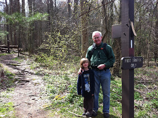
Tom, Rich, Molly, Wyatt, Mike, Shannon (part), Brandon (part)
As they say, success breeds success, and the same is true when hiking. Having successfully completed 8 miles, the next segment from Route 30 back to Old Forge was longer, again a southerly route, and seemed like something we could accomplish with ease. At 11 miles, it was 2 miles longer than the first trek, and we got a later start, but we knew that we would finish before dusk. On this second leg of our trek, Shannon and Brandon joined us for part of the hike, and Molly was a new addition to our hiking team.
 The trailhead sits at 1000 feet, later climbs to 2000, and then begins to slope back down to 1000 feet near the end. At times, the trail hugged the ridge of the mountain and there were incredible rock formations—the geologic reminder that we were walking by millions of years of history.
About 8 miles into the hike, we passed Chimney Rock—another beautiful formation. Tom and Wyatt took a few minutes to explore the cluster of rocks, while the rest of us looked out over the valley below South Mountain.
The trail is in the thick of Michaux State Forest, which is beautiful even in the early Spring. Michaux spans three counties and totals more than 86,000 acres. These timber lands are managed and supervised by PA Department of Conservation and Natural Resources (DCNR) Forest District Office staff. You can find out more about Michaux and DCNR at this link: http://www.dcnr.state.pa.us/forestry/stateforests/michaux/index.htm
We were joined again by Shannon and Brandon nearing the end of our hike--and made a long descent down the mountain---and headed off for dinner at a nearby country restaurant.
About 212 miles to go!


No comments:
Post a Comment